URBAN DEVELOPMENT
In the Middle of Europe
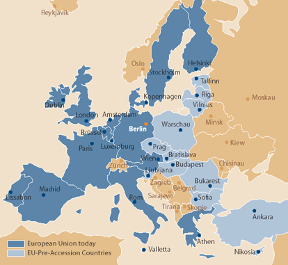
With the fall of the wall, Berlin became the youngest European capital and Metropolitan region. As a consequence of war and division, for half a century the city had been located at the political fringe. In the course of the political changes of the last about 15 years, Berlin regained a central position in Europe, located on the East-Western axis between Moscow, Warsaw and Paris, and in North-South direction on the line Stockholm, Prague, Vienna and Budapest. In view of the central geographical position and its particular history, in the wider European Union Berlin appears most predestined to form the bridge between East and West, North and South.
The Extension of the European Union:
Berlin in the centre of a larger Europe
The Capital
As the new seat of both parliament and government Berlin grew to be the cosmopolitan and internationally appealing capital of the Federal Republic of Germany. The relocation of the government brought about extensive investments in buildings and infrastructure and initiated the establishment of numerous national and international institutions in the city. Meanwhile, most of the foreign embassies moved to Berlin. A lot of them returned to their pre-war location on Pariser Platz or the "Diplomats' District" near Tiergarten. Remarkable architectural solutions add to the townscape.
Many German and international enterprises, associations and NGOs (Non Government Organisations) transferred their representations to Berlin.
Along with the government came also the media: More and more news broadcasting companies, press and media enterprises settle in the city.
The Metropolitan Region
After the fall of the wall the communication lines between the city and the surrounding countryside that had been interrupted for decades were re-established. Since 1990, approximately 240,000 people moved from Berlin to the hinterland and about 90,000 from there to the city. Each day, about 106,000 people commute to Berlin and around 48,000 go the opposite way.
The Metropolitan Region Berlin / Brandenburg with Berlin in the centre and the adjacent districts of the Federal Land Brandenburg at the periphery amounts to an extension of approximately 5,370 sq. km, with - in 2002 - 4.3 million people living there, 140,000 more than in 1990. The city of Berlin, in 2002, had about 3.4 million inhabitants living on a surface of about 891 sq. km.
When taking decisions on housing, working, shopping, culture, leisure time or investments, inhabitants and enterprises of the region orientate less and less on the political borders of the city and the surrounding communities. But also for others, the Metropolitan Region of Berlin is getting increasingly attractive for settlement and investments.
Metropolitan Region Berlin
A City in Transition
After the reunification in 1990, a lot of the problems that had been resulting from the division were solved by an enormous effort of re-organisation, the stock of buildings was renewed and complemented, and the technical infrastructure widely modernised. In many fields, the new quality of the city can already be experienced, but the transition process is not yet finished. The dynamics of change are still on a high level, the development of the city is still in progress.
Urbanity
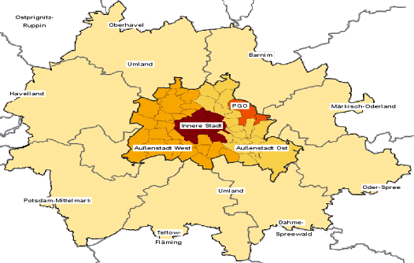
Within the city rail circle Berlin disposes of an urbane, functional and socially mixed inner centre with prominent significance for the whole city. It constitutes the main work centre, and also the central service institutions are located here. For visitors from outside, investors and inhabitants the central area defines the image, importance and attractiveness of the whole city. The overall urban significance of the centre is to be extended and boosted.
Regional centres
Berlin is composed of 12 city districts, each of them disposing of an own centre for communal services and shopping, leisure time and recreation facilities. This polycentric structure strengthens the local identity and guarantees for a spatially balanced, easy to reach provision of the population. The regional centres are to be stabilised and extended.
The Green City
Berlin is a very "green" city. Altogether, around 45% of the overall city surface are undeveloped, 16 hectares of it being forest, 4,600 hectares agricultural land, 3,500 hectares allotments, 5,700 public parks and 6,000 hectares water stretches. These areas are important for the climate, but also for the recreation and attractive leisure time activities of the population. They are to be maintained and extended.
Sufficient Residential Space
With a stagnating population and 1.87 million dwellings the city offers a satisfactory housing market in terms of quantity. Since 1990, about 10 billion Euro have been invested in maintenance and quality improvement. A further development appears to be reasonable only, when a strengthening of personally used private and collective home ownership, a qualification of disadvantaged neighbourhoods and a strengthening of the centre as residential location is intended.
In some boroughs, for a growing share of the population the economic and social change induces an insufficient protection in terms of work, training and social integration. The Neighbourhood Management aims at stabilising and sanitising these areas.
The vacancy of dwellings and infrastructure institutions in the large housing estates at the outskirts of the city put these areas at risk and require special attention. It is intended, with the help of an urban reconstruction strategy, which in certain areas includes also a demolishing of sites, to succeed in a permanent marketability of these settlement areas.
Inner-urban Mobility
The favourable city structure leads to rather short distances to work, supply and education centres. The public transport net is dense. After 1990, there were substantial investments in the transport infrastructure. The railway network of underground, city railway and regional trains was extended by 183
km to 748
km, the road network by 170
km to 5,380
km approximately. Nevertheless, the development is not yet completed and there are still differences between the eastern and western part of the city.
At present, the share of private cars in the number of daily journeys amounts to about 41%, the share of public transport is about 27% and the one of journeys undertaken on foot or by bicycle at 32% approximately. In spite of the fact that, since 1990, the population in the Metropolitan region increased by just 3%, traffic volume increased by almost 20%. The risen stress of the urban living space and the environment through noise and air pollution and gases hazardous to the climate is a problem still unsolved.
High-performance Long-distance Communication Lines
With the expansion of the long-range railway junction and its communication lines on road, rail and waterways to the West, North and South, Berlin is very well re-integrated in the trans-European Network. In view of the eastern enlargement of the EU the links to the important central and eastern European cities still have to be enhanced. The projected "International Airport Berlin-Brandenburg" will provide the pre-requisite for an international air traffic crossing point in the Metropolitan region.
Additional information on Berlin
Berlin images for free download