
Documentation / Online Handbook
![]()
![]()
![]()
Introduction
On their way into the new millennium, modern communities have to focus on sustainable strategies to face future challenges in the social, economic and, of course, environmental arenas. One of the main aims is the development of balanced regions in which all planning aspects are taken into account. This can only be achieved through an integrated planning system. With the ever increasing relevance of environmental issues within this field, it has become necessary to provide political decision-makers and planners with easy access to up-to-date and high quality information. This is even more important and requested for large urban areas, where the antropogenic pressure and impact is increasing. The state of environment and quality of life will be an important factor in the process of competition between the regions of the world.
The development of specific information tools for environmental information and monitoring, allow local administrations to take environmental factors into account as widely as possible and to integrate environmental concerns into various policy areas. Reliable information on the environmental conditions are a crucial factor both for planning and for political discussion. This information is distributed throughout many administrative areas. This data, as well as the expert knowledge of specialists, are required in a coherent and transparent form.
As a result of the need to identify, pool and aggregate existing environmental information in an efficient and accessible manner, local authorities throughout Europe, passing first through the creation of simple data base, have developed different types of Environmental Information Systems. In an E.I.S these data are geo-referenced and can be elaborated and presented for different uses.
Environmental Information Systems
Environmental Information Systems (E.I.S) are defined as follows:
An E.I.S., normally computerized, is a data capture and processing system used to provide the latest information for administrative and planning work. Media-specific data are usually allocated to their own information system or layer (e.g. soil, water). Other information systems are devoted to cross-media instruments (e.g. environmental impact assessment, environmental planning, ecosystemic research). E.I.S. provide the raw material for reporting and mapping the state of the environment, and for its evaluation (zones worth conserving, environmental loads, zones of conflicts), as part of the planning process.
(from Glossary of Environmental Terms for Urban and Regional Planners, Umweltbundesamt Nov. 1995).
The main task of an E.I.S is to aggregate and evaluate data in order to get comprehensive, general data obtained mainly from expert related individual data. The evaluation, elaboration and interpolation of numerous indicators requires the development of special methodologies, whose implementation is supported by information tools. The results can be presented in various media with different accents and forms.
However, fragmentation of data coverage, of responsibilities for monitoring, different data formats and not least, the difficulties of knowledge and accessing existing information, remain as a common and important problems.
The ENVIBASE Project
The ECOS / Ouverture Programme of the EU supports the cooperation between the governmental authorities in West and East European regions and the countries that were earlier part of the U.S.S.R. Local business development, planning, environmental protection and energy are all areas supported by the EU.
This exchange of experience, the ENVIBASE project, evolved from various conferences throughout Italy and personal exchanges between the Berlin and Moscow administrations when the Environmental Atlas of Berlin and the new Environmental Information System of Berlin were presented. The great interest generated for this approach showed a deeper knowledge of its organisation and methods, as well as the comparison with the local situation of all partner authorities, to be indispensable.
A particular challenge and opportunity was presented by the group from Moscow. The start of a dialogue and exchange of experience from ex-Soviet states made possible a new form of co-operation that in earlier years was not politically possible. Especially important is the area of environmental planning where information earlier was not made available to the public. From shared interest, and not merely because Berlin is confronted with the same problems, were the overcoming of data deficiencies, the organisation of an information system with meagre resources and the work in general under difficult administrative conditions discussed.
Data and information about environmental quality were not public in the former USSR. They were only collected in a limited fashion. But collecting, assessing and publishing of environmental data is necessary to improve the bad environmental situation. Creating public consciousness and the base to work out ecological orientated redevelopment and urban development plans requires environmental information. Dealing with the contents and methods of ecological fundamentals will improve the consideration of environmental issues.
The contents and results of this co-operation are important and necessary for most of the Eastern as well as for the Western European countries. A dissemination of the results and experiences of this project supports the awareness of the necessity to work out ecological fundamentals for sustainable urban development.
The project may serve as model for an effective exchange of knowledge and experience and might encourage other cities and regions to start closer co-operation with each other.
Partners and aim of the ENVIBASE project
The metropolitan areas Berlin, Athens, Lombardy region, Rome and Moscow have therefore initiated a joint project focusing on this topic. The project builds upon the consensus decision that through the development of specific information tools for environmental planning and monitoring, local administrations can be encouraged to include environmental concerns in the creation of policy. In addition, the public must be informed about the state of the environment, as well as being incorporated into the planning process. All project activities are based on the data-systems (Geographical and environmental information systems) which are in development in the respective cities. The ongoing work is stimulated by the project.
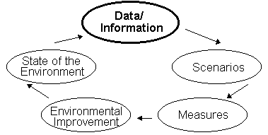
The main aim of the project is to contribute to an improved system of sustainable and integrated environmental monitoring and planning through the development of methods and instruments. Emphasis is put on the importance of including both the gathering and the use of environmental data into the following decision-making system.
Fig.: Monitoring the environment
The objectives of the project can be summarised as follows:
Technical objectives
Political Objectives
The project corresponds in all points with the aims of the "UN Conference on the Environment" in Rio de Janeiro in 1992, and the programme "For a sustainable and ecological development" which was passed in 1992 by the EC Commission. It also supports the "Charta of European cities and towns towards a sustainable development" settled in Aalborg 1994 (Aalborg Charta). The main objectives are:
Project activities
Workshops
A series of workshops was held aiming at both a comparative analysis and discussion about the requirements of up-to-date environmental information systems for metropolitan areas. The main objectives described in the proposal were to improve the access to and to increase the transparency of environmental information in the Project partner cities and to pass on this knowledge to other EU cities. Information and evaluation methods of the different cities should be compared and similarities in the creation of ecological planning bases should be developed. The possibilities of creating common methodologies and instruments for different regional situations should be investigated.
Each of the partners hosted a meeting focusing on different environmental issues such as soil, climate, water, land use, biotopes as well as air and transport-induced air pollution. Local experts and consultants are being integrated into the project in order ensure the quality of the contributions.
| Handbook: | As a main result all contributions will be documented in a detailed handbook. | |
| Pilot actions / case studies: |
Each city illustrates technical sessions through the presentation of a representative example reflecting their local approach. | |
| Working groups: | Working groups are being created to focus on more specific aspects of the project. | |
| Editing group: | Joint compilation of a handbook presenting information and results obtained during the project as well as conclusions drawn from the joint analysis. | |
| Publication / Internet: | Development of strategies for a sound publication of the project results through telematics. | |
| GIS Questionnaire: | A questionnaire about the technical analysis of the Geographical Information System has been created by an expert consultant. Evaluation and analysis of the results will be done within the project group. | |
| Networking: | Several initiatives are aiming at liasing the project activities with various other projects/institutions i.e. the activities of EUROSTAT. | |
| Project leader: | Berlin | Berlin Ministry for Urban Development, Environmental Protection and Technology |
| Project partners: | Athens | AEDA - Municipality of Athens Development Agency |
| Lombardy | Region, Settore Urbanistica & Ambiente | |
| Moscow | Moscow Institute of City Master Plan | |
| Rome | Commune di Roma, Department X | |
Carrying out the Project
The project started in late 1996 and had a duration of two years. Five workshops took place, one in each partner city, where an intensive exchange of experience took place. Each workshop had a focal topic where each partner city contributed. They were held in the following order:
| Berlin: | 1/1997 | Soil and climate |
| Moscow: | 5/1997 | Water |
| Rome: | 9/1997 | Biotopes and land use |
| Athens: | 12/1998 | Air |
| Milan: | 1/1998 | Traffic induced air pollution |
These focal points were completed by discussions on more general methodological aspects of creating Environmental Information Systems such as:
| conception | Discussion of the necessary environmental data base for the use in planning, area relationships, scale |
| data collecting | Quality of data, format, availability, restrictions, continuously or discontinuously collection, up-dating |
| methods of evaluation | Political conditions, the problems of critical levels , administrative co-operation, aims of evaluation, transparency |
| data processing | General and specific demands to information systems, structure , administrative organisation, Hard- and Software, financing, staff, Geographical Information Systems (GIS), methods |
| results</td> | Kinds of results, data, maps, texts, requests and standards in environmental cartographics, digital or analog form of presen-tation, further application, technical conditions and possibilities |
Further emphasis in the workshops was put on the demonstration of the Environmental Information System of the host city. All the workshops were accompanied by Public Relations activities like press conferences, exhibitions and public workshops. An editing group was founded in the first workshop and developed the structure of the handbook. The members continued their additional work during all the workshops and as well in the time between the workshops. They were responsible for the gathering and editing of the contributions. This handbook documents, structures and summarises what happened in the workshops.
The handbook
In the first chapter the project partners are introduced by giving a brief description of the region, the urban structure and economy, the environment and the developments as well as a description of the administrations involved. It became clear that although the partners all came from public administrations their real competencies vary greatly. The partners from Athens were from a recently founded agency from the general environmental division. They co-operated closely with an national agency. The Berlin partners represented a group specialised on Environmental Information Systems. The Lombardy partners came from Urban Planing, the Moscow partners from an environmental planning group inside an institute for urban planning. Against this, the Roman partners were more green planners and involved in nature protection. These very different backgrounds of the partners will explain the sometimes different approaches towards specific topics.
The second chapter presents an analysis of the different approaches to Geographical Information Systems. As we were conscious about the difficulty to analyse this complex topic in a systematic and comparable way, we decided to work out an unified questionnaire prepared by an external and long-experienced GIS-expert. One or more GIS-experts of the partners filled in the questionnaire so that we have collected much detailed information about the hard and software equipment, user structure, development costs and so on. The main results are summarised in this chapter. But not only the figures were asked for. More important were the experience and the conclusions for the future and the advice given for future users of GIS. Because of the small number of questionnaires it could not be evaluated quantitatively but qualitatively. Further, the costs in term of financial and personnel resources are described.
The third chapter is the most extensive chapter and consists of the detailed analysis of six environmental parameters climate, soil, water, biotopes and land-use, traffic and air quality for the five partner cities. In each of the thirty-five subchapters you will find a general overview of the problem and a systematic description of the existing data, the used evaluation methods, the results and their application. For a better overview, all described data are also presented in tables. For each topic example maps from the different partners are included. At the end, analysing and comparing the different information/data available by the partners, recommendations are made for the most commonly produced and important maps. Indicating maps for example, which can be produced by using the methodology of one partner on data already available.
In the conclusions and the outlook we tried to summarise the results and our experience in comparison with the aims described in the application.
![]()
![]()
![]()